%20of%20geologybar.JPG)
Yellowstone
National Park covers 2,221,766 acres, which is roughly the size of the
state of Connecticut. Most of the park is located in the northwestern
corner of Wyoming, but a small portion overlaps that state's boundaries
with Montana and Idaho. The park is comprised primarily of high, forested,
volcanic plateaus that have been eroded over - the millennia by glaciation
and stream flow and that are flanked on the north, east, and south by
mountains. The Continental Divide traverses the park from its southeastern
corner to its «-western boundary. The elevation of the park averages
8,000 feet, ranging from 5,282 feet in the north, where the Gardner
River drains from the park, to 11,358 feet in the east, at the summit
of Eagle Peak in the Absaroka Range.
|
"The Wonders
of Yellowstone"
- 98 Minutes
-
~Telly Award Winner for Nature
and Wildlife~
Two years in the making
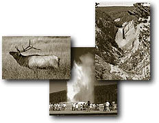
and just released, "The Wonders of Yellowstone" video
has been highly requested, produced in DVD format and is now available.
Take a complete tour of Yellowstone National Park as our Narrator
Cathy Coan guides you to all the wonders of the park including
all the geyser basins, wildlife, waterfalls and much more.
We previously sold
travel packets but these packets, maps and trail guides are all
available at the park for free or minimal charge.
More
Info or Order Online |
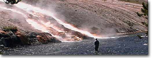
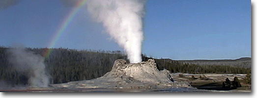
The Four Types of Thermal Features - Yellowstone Association
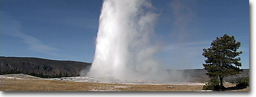
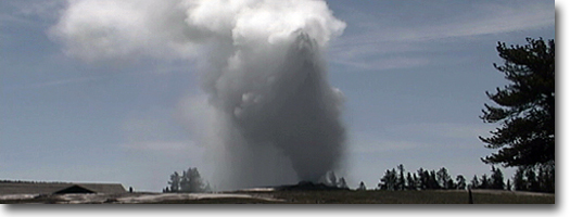
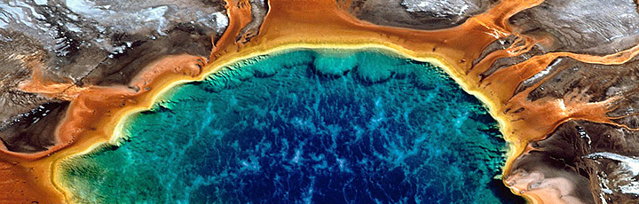
Geyser: A geyser is a hot spring
with the intriguing habit of tossing underground water into the air.
Water falling as rain or snow seeps through porous layers of rock. Eventually
that water comes into contact with extremely hot rocks that have been
heated by a large body of molten material, called magma, underneath
the park. This hot water then rises through a series of cracks and fissures
underneath the surface of the Earth. In a sense, these fissures are
the "plumbing system" of a thermal feature. A geyser is the
equivalent of a giant pressure cooker; even though the temperature of
water deep down may be well above boiling, the weight and pressure of
the water above prevents that boiling from happening. Eventually, though,
the pressure builds enough to push the water in the upper reaches up
and out, causing an overflow. That overflow, in turn, relieves the pressure
on the super-heated water below, causing it to flash into steam. That
flash, that explosion through a narrow, constricted place in the rocks,
is what sends water shooting into the air,
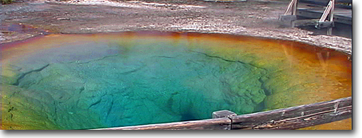
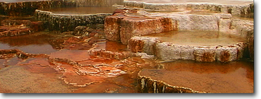
Hot Spring: Hot springs let off enough heat by boiling or surface evaporation to
avoid the kind of steam explosions common to geysers. Some of Yellowstone's
hot springs take the form of quiet pools. Others are flowing. The waters
of many of this latter type, such as those at Mammoth Hot Springs, become
charged with carbon dioxide while underground, creating a mild carbonic
acid. That acid dissolves underground limestone rocks and carries the
mixture to the surface of the Earth. Once on the surface, the carbon
dioxide gas escapes. Without carbon dioxide, the water is less able
to carry the dissolved limestone. The dissolved limestone precipitates
out, creating beautiful travertine terraces. In areas underlaid with
volcanic rock, as opposed to more easily dissolved limestone, a modification
of the plumbing system-perhaps through small earthquakes-can easily
turn a hot spring into a geyser.
Fumarole (also called steam vent): In simplest terms, a fumarole is a vent in
the Earth's crust. The supply of water around fumaroles is not as plentiful
as in hot springs and geysers. Modest amounts of groundwater come into
contact with hot rocks underground and are turned to steam. This steam
rushes up through a series of cracks and fissures and out the vent,
sometimes with enough force to create a loud hiss or roar.
Mudpot: In this feature, steam rises through groundwater that has dissolved
surrounding rocks into clay; various minerals in the rocks make wide
variations in the color of the mud. More often than not, such water
is quite acidic, which help is the breaking down and dissolving process,
Geology - Grand
Teton Historical Society
The Washburn Range in Yellowstone forms
the skyline between canyon village and tower fall. From a parking area
on Dunraven Pass, an altitude of 8,850' above sea level, an old road
leads to the summit of Mt. Washburn at 10,243'. The 1,400' climb has
much to recommend it, including geology.
Seen along the road is a dark breccia
consisting of anglular volcanic stones, embedded in a fine angular matrix.
This breccia formed some 50 million years ago when watery mixtures of
ash and rocks flowed down mountain slopes onto then tropical lowlands.
There are countless volcanic mudflows that make up the Washburn Range
and mountains to the east. All were deposited over a period of 10 million
years.
Bedding planes separating breccia layers
are instructive. In Mount Washburn and surrounding peaks, all slope
northward. Shouldn't some slope southward? Didn't debris also flow down
the south slopes of ancient volcanoes? Well, where is the evidence?
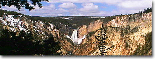
We search to the south for these flows
in vain. Far below us is Washburn Hot Springs, the Grand Canyon of the
Yellowstone, Hayden Valley, and Yellowstone Lake. The nearest recognizable
peak is Mount Sheridan, in the Red Mountains, 37 miles south of Mount
Washburn. The summits of Washburn and Sheridan are within 65 feet of
each other in elevation.
 Volcanic
breccias sloping only north combined with Volcanic
breccias sloping only north combined with
gently rolling plateaus extending south to the Red Mountains suggest
that the Washburn Range is only a remnant; the northern remnant of a
much larger and higher range that extended far to the south. This range
is a part of the Absaroka volcanic field, which also forms the mountainous
terrain east of Yellowstone Lake. But how to account for the missing
southern part of the Washburn Range? The answer lies down on the plateaus
forming the heart of Yellowstone. Road
cuts between Dunraven Pass and Canyon Village glitter in the sun. The
rock is rhyolite, the lava form of granite. It differs fundamentally
in its composition, origin, and age from the volcanic rocks composing
Mount Washburn. Shiny black volcanic glass (obsidian) causes the glitter.
Tens of rhyolite lava flows were erupted
one after another in central Yellowstone. Canyon Village is built on
one. Elephant Back Mountain, west of Lake Hotel, is another. Several
flows make up the plateau between Canyon Village and Norris, and several
more bound the western margins of Yellowstone Lake. Flows enclose Lewis
and Shoshone lakes; they form the wooded boundaries of the geyser basins.
Many streams follow seams between flows of different ages.
Lava flows can be readily dated. They
contain various radioactive elements which decay to form daughter products.
By measuring the relative amounts of parent material and daughter products
and knowing the rate of change from parent to daughter, a geochronologist
has a radioactive clock for dating the ages of flows. Analysis, though,
is not simple and geologic dates are usually followed by a fudge factor
such as +/- 6,000 years. Between the Washburn Range and the Red Mountains,
lava flows range in age from about 500,000 years to 100,000 years. They
are much younger than the 50 million-year-old Absaroka volcanics.
To summarize, the Washburn Range is made
of debris flows preserved in the north flank of an old dissected volcano.
This volcano and the Red Mountains, about 37 miles to the south, are
joined by an arc of Absaroka volcanic mountains east of Yellowstone
Lake. They form, in aggregate, a sort of geologic horseshoe open to
the southwest. Rocks forming the horseshoe are at least 50 million years
old. Cradled within the horseshoe are half a million years old or younger.
Both the large difference in age and fundamental, chemical composition
show older and younger volcanic rocks are unrelated, though they to
occupy common ground.
Early students of Yellowstone geology
failed to recognize the age break between the Absaroka volcanic
breccias and the much younger lava flows of the Yellowstone Plateau.
They believed that a continuum of volcanic activity linked the Absaroka
voicanics and the lava flows.
This comfortable scenario was shattered
by a Harvard graduate student, Francis R. Boyd, who chose Yellowstone
for his thesis project. Boyd did his field work in the 1950s. During
his studies he saw that some of the so-called lava flows were something
quite different-they were welded tuffs. Welded tuffs are products of
explosive volcanism. Siliceous lavas charged with dissolved gas literally
explode out of volcanoes as mobile froths flowing rapidly across surrounding
landscapes. When such ash flows settle, they quickly begin to compact
and if the ash retains enough heat to re-fuse, the rock becomes a welded
tuff. Even after compaction, the individual shards are visible under
a microscope or even to the naked eye, although they may be severely
contorted by flowage and compaction.
Before Boy&s time geologists were
only beginning to recognize welded tuffs and their distinctive qualities.
The significance of his work, published in 1961, was that a previously
unrecognized volcanic event in Yellowstone had produced violent explosions
and staggering volumes of volcanic ash, later consolidated into welded
tuffs. He demonstrated that these tuffs covered thousands of square
miles of Grand Teton and Yellowstone and that they rimmed a large tectonic
basin in Yellowstone that contain even younger lava flows.
The explosive volcanic events that produced
these tuffs were unbelievably large and violent-many times greater than
the 1981 eruption of Mount St. Helens. They destroyed the southern half
of the Washburn volcano and whatever mountains existed between Mt. Washburn
and the Red Mountains. Geologists have identified streaks and thin layers
of Yellowstone volcanic ash from as far away as California, Saskatchewan,
Iowa, and the Gulf of Mexico. Volumes of ash blasted into the stratosphere
circulated around the globe and must have altered the weather worldwide.
|