%20of%20xccanyonbar.JPG)
South Rim Trail
(formerly the Savage Trail)
Length from Chittenden Bridge to:
Upper Falls viewpoint - 0.3 miles, one way.
Uncle Tom's Trail - 0.6 miles, one way.
Artist Point - 1.4 miles, one way.
Sublime Point - 2.5 miles, one way.
Elevation change: Trailhead at 7,800 feet (50-foot gain).
Trailhead: Located at the Chittenden Bridge parking area, 2.3 miles
south of Canyon Junction.
The South Rim Trail is a wonderful hike
for early summer mornings. The morning light is to a hikers' back, when
viewing the canyon, and the light provides shadows, relief and changing
colors. The trail wanders through lodgepole and limber pines but provides
striking viewpoints along the way. The South Rim Trail begins at Chittenden
Bridge and is partially paved.
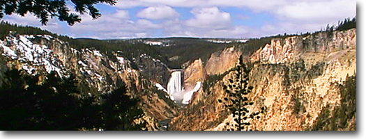
It skirts the south rim of the canyon, runs past Upper Falls, Uncle
Tom's Trail (see Uncle Tom's Trail for description), Lower Falls, Artist
Point (see Artist Point Trail for description), and access to Lily Pad
Lake, ending at Sublime Point.
The trail is best hiked early in the
morning while the sun remains to the east, thus providing the best light
conditions for photography and viewing.
Artist Point Trail
Length: .1 mile, one way.
Elevation change: Trailhead at 7,680 feet (no noticeable elevation change).
Trailhead: Located at Artist Point Trailhead at the end of the South
Rim Drive, which begins 2.3 miles south of Canyon Junction.
This is a very short walk from the parking
area to a viewpoint on the South Rim. Artist Point is considered to
be the best vantage point of the falls and canyon, which has inspired
artists such as Thomas Moran and Albert Bierstadt.
The canyon began forming almost 590,000
years ago when a large magma chamber flowed over what now is the canyon
area. Hydrothermal springs developed under the flow and began weakening
and altering the rhyoiitic rock. As time went by, the Yellowstone River
channel began etching and deepening into the soft rhyolite.
The Upper and Lower falls were formed
because hard, resistant basalt layers at the brink did not erode. Today,
the canyon is about 800-1,300 feet deep, 1,500-4,000 feet wide, and
20 miles long
Cascade and Grebe Lake Trails
Length from Cascade Lake picnic area to:
Cascade Creek Trail Junction 0.9 miles, one way.
Cascade Creek Trailhead (spur trail)
- 2.3 miles, one way.
Observation Peak Trail Junction - 1.9 miles, one way.
Observation Peak Summit (spur trail)
- 4.2 miles, one way.
Cascade Lake - 1.6 miles, one way.
Grebe Lake - 4.2 miles, one way.
Canyon Village Junction to:
Cascade Lake - 2.6 miles, one way.
Grebe Lake - 4.6 miles, one way.
Cascade Lake picnic area (spur trail) - 2.4 miles, one way.
Grebe Lake Trailhead on Norris-Canyon Road to:
Grebe Lake 3.0 miles, one way.
Elevation changes from Cascade Lake picnic
area at 8,020 feet to: Cascade
Lake, 40-foot loss Grebe Lake, 28-foot gain Observation Peak, 1,377-foot
gain.
Trailheads: 1) Cascade Lake picnic area, 1.5 miles north of Canyon Junction.
2) Grebe Lake trailhead parking area, 3.3 miles west of Canyon Junction.
3) Cascade Creek trailhead, located a quarter mile west of the Canyon
Junction on the Canyon-Norris Road.
Three trailheads access these lakes but
the best-and certainly the most scenic-access to Cascade Lake starts at Cascade Lake picnic area, nearly a
mile and a half north of Canyon Village on the Canyon-Tower Road. The
picnic area is on the west side of the road, in a dark stand of lodgepole
pine. The trailhead begins on the far western edge of the picnic area
loop road.
Shortly after leaving the picnic area,
the trail emerges into several open meadows. After nearly a mile, the
trail joins Cascade Creek and the trail junction to Cascade Creek Trail.
The Cascade Creek Trailhead begins nearly a half mile west of the Canyon
Village Junction, just past the Park Service housing compound. This
trail is not as scenic as the entrance from Cascade Lake picnic area
because it lacks the spacious, wildflower meadows. It also is used for
trail rides, so expect horse traffic. During the winter. Park Service
employees use this trail to the Cascade picnic area and the Grand Loop
Road back to the housing area as a ski loop. Because there are no overnight
winter accommodations at Canyon, however, it is not convenient for most
cross-country skiers to use.
Just past the Cascade Creek Trail Junction,
the trail opens into a large open meadow, where Cascade Lake (7,980
feet) is on its west side. This meadow often is inhabited by moose and
bison. At the northeast corner of the lake is another trail junction
that leads to Observation Peak, which can be seen from the meadow. This
spur trail climbs nearly 1,400 feet over two miles to the summit of
Observation Peak (9,397 feet). The forest surrounding this area and
the peak itself burned during the 1988 fires, and much of the forest
remains as standing skeletons. Only occasional trees along the margin
or small islands of untouched trees remain. The hike up to Observation
Peak provides excellent views of Cascade Lake and, in the distance,
Hayden Valley. As the trail continues around the south and west of the
summit, a hiker will also get views of Grebe Lake.
Cascade Lake is a popular and easy destination
for fishing. This 36-acre lake is only 27 feet deep but contains a good
population of cutthroat trout. It also is considered to be the only
lake in the Yellowstone drainage to have grayling.
From Cascade Lake, the trail continues
on for about two miles through forests and meadows and, crossing into
another drainage, to Grebe Lake (8,020 feet). These meadows usually
are wet, mucky and mosquito-ridden in the spring but are more accessible
in late summer and early fall.
The Bureau of Fisheries operated a fish
hatchery on the eastern end of Grebe Lake from 1933 until the mid-1950s.
This hatchery stocked most of the lakes in the area, the majority of
which previously were considered barren offish. Grebe Lake is a roundish
lake, about 156 acres in size and 39 feet deep, and is said to contain
grayling and rainbow trout. This lake forms the headwaters for the Gibbon
River, whereas Cascade Lake forms Cascade Creek, which drains into the
Grand Canyon near the Upper Falls.
The most popular trail to Grebe Lake
begins about 3.3 miles west of Canyon Junction on the Norris-Canyon
Road. The trail is the original road to the Grebe Lake fish hatchery.
The trail uses the old road for the first two miles but veers to the
west, leaving the road for the remaining mile to Grebe Lake. The trail
junction, on the east shore, leads either to Wolf Lake to the west or
Cascade Lake to the east.
|