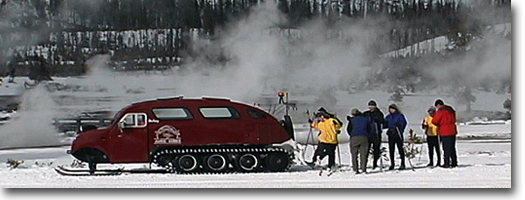
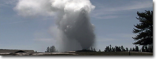
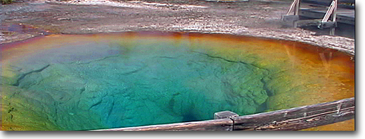
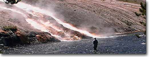
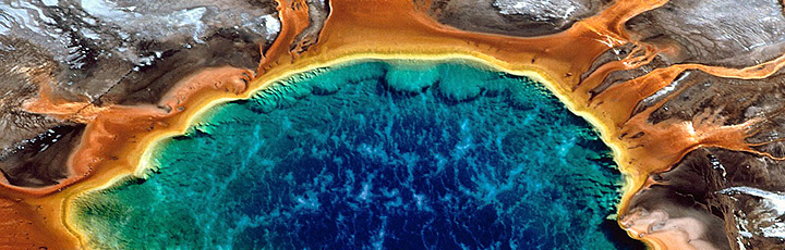
Fairy Falls - Imperial Geyser Trail Two approaches are available to access the Fairy Falls Trail. Either approach merges at the junction. (During winter, however, the Freight Road has been open to snowmobiles and the trail junction can be accessed by that means.) The old freight road can also be bicycled, but due to fine obsidian sand it is difficult with narrow tire bicycles. From the junction, it is a 1.5 mile hike to the Falls. This trail, prior to 1988, wandered through a dense, old-growth lodgepole and spruce forest. The 1988 fires, however, burned this area extensively and it now is open and exposed, except for the large, burned skeleton trees that once made up the forest. The 200-foot Fairy Falls is hidden in an alcove-like grotto and it is not fully visible until it is approached at its base. The falls is a slender and graceful waterfall, which plunges over the lip of a rhyolitic formation. The lower half of the falls strikes the rock wall and forms a lacy descent to a small pool at its base. During winter, the falls becomes encrusted in a large, Gothic-looking icicle. This trail is one of the Park's more popular winter destination ski trails. From Fairy Falls, the trail crosses Fairy Creek and continues north for about 0.4 miles to a junction in a small meadow. The trail heading west leads to Imperial and Spray geysers at the base of Twin Buttes (recently referred to as Marilyn Mon-roe Mountains). Spray is the first geyser and a thermal stream originating from Imperial has to be cautiously forded. The geyser is in near continuous splashing. This has resulted in a large algae and bacteria mound around its vent. A log fell across the vent, giving the whole formation an unusual appearance. Imperial Geyser became active in 1927 and, two years later, a contest among visiting newspaper men named this feature. The eruptions during that year were so violent-reaching 80 to 150 feet high-that its plumbing system probably was damaged. The geyser went into dormancy until 1966, when it began a near-constant eruption. In 1985, though, Imperial again went into dormancy, but it does continue to boil and churn. Even without its constant eruption, the 75-by-IOO-foot alkaline pool is known for its clear, blue-colored water. The discharge has been estimated at 500 gallons per minute. By continuing north from the junction at the small meadow, the trail follows Fairy Creek through Fairy Creek Meadows and back to Fountain Flat Drive, north of Goose Lake. This trail once was the road for Model-T traffic accessing Fairy Falls. It is now another alternate hike to Fairy Falls and is about 2.4 miles from the freight road. Mystic Falls and Biscuit Bason Overlook At the far end of Biscuit Basin boardwalk, opposite Avoca Spring, a dirt trail leads west into the trees. Just after entering the trees, a trail branches to the south. This trail returns to Old Faithful (see Upper Geyser Basin Trail for description). After 0.3 miles, the trail divides again. Trail to Biscuit Basin Overlook: The trail to the north leads to the view point, then beyond to the Little Firehole Meadows. Just after the junction, the trail begins a series of switchbacks up the rhyolitic cliff, about 0.5 miles to Biscuit Basin Overlook. From the overlook, it is possible to view Biscuit Basin- the blue spring is Sapphire Pool. Following the Firehole River upstream, it is possible to observe the eruptions of Riverside, Grotto, Grand, Castle and Old Faithful geysers. To the south lies Black Sand Basin, and an eruption of Cliff Geyser or even an occasional eruption of Sunset Lake can be observed. Immediately below Biscuit Basin Overlook is further evidence of the 1988 fires. On September 7 of that year, the Northfork Fire swept through and burned a large portion of the Old Faithful area. Only isolated islands of trees, especially along moist stream bottoms, were left relatively untouched. Look closely for large patches of downed trees lying and pointing in the same direction. This is the result of severe tornado-like winds blowing and uprooting the shallow-rooted lodgepole pines. This blowdown occurred before the 1988 fires. Also below the overlook is the confluence of the Little Firehole River (Mystic Falls), Iron Creek (Black Sand Basin), and the Firehole River (Old Faithful). Look just to the left of the overlook on the projecting rocks of the outcropping. The white edges on the rocks indicate frequent lightning strikes. Lightning does strike twice in the same location. This is a good indicator that this point should be avoided during thunderstorms, which are frequent during summer mid-afternoons. From Biscuit Basin Overlook, the trail continues along the ridge and eventually to the Little Firehole Meadows and Fairy Falls. But after about a tenth of a mile, an unmarked trail descends to Mystic Falls, about 0.8 miles from the overlook. Trail to Mystic Falls: From the Biscuit Basin 0verlook/ Mystic Falls junction, the west trail leads to Mystic Falls along the Little Firehole River after about 0.4 miles from the junction. Just after the Biscuit Basin Overlook/Mystic Falls junction is another junction. This splitting crosses a creek over a small bridge and leads to Summit Lake (see Summit Lake Trail for description), 7.1 miles up a steep incline. The main trail follows the stream to the base of Mystic Falls. The cascade is an impressive 100-foot drop of the Little Firehole River, as it descends from the Madison Plateau. At this point, the trail rejoins the Biscuit Basin Overlook loop trail and begins a few switchbacks through the burned forest to the ridge. Summit Lake Trail At the far end of Biscuit Basin boardwalk, and opposite Avoca Spring, a dirt trail heads west into the lodgepole trees. Just after entering the trees, a trail branches to the south. This trail returns to Old Faithful (see Upper Geyser Basin Trail for description). After 0.3 miles, the trail divides. The north trail leads to Biscuit Basin Overlook (see Mystic Falls and Biscuit Basin Overlook Trail for description), while the west trail continues up the drainage to Mystic Falls. Just after the Biscuit Basin Overlook/Mystic Falls junction is another junction. The trail splits off for Summit Lake, crossing the Little Firehole River via a small bridge. From the junction, the trail begins a steep ascent of nearly 1,200 feet to the lake. The route is not interesting, as the trail wanders through a dry, sparse lodgepole forest. Even most of this burned during the 1988 fires. The trail follows the intermittent streambed of Summit Lake and this usually is dry by midsummer. Summit Lake (8,552 feet) is aptly named, as it rests next to the Continental Divide. It is a small lake, fewer than 30 acres in size and rimmed by lodgepoles and a small meadow on its southern edge. The trail continues on from Summit Lake and heads directly west to the west boundary for an additional 8.75 miles. But just after Summit Lake, the trail crosses the Continental Divide; on the other side are a series of small lakes. Little Summit Lake, to the north, is one of them, and nearby are a series of small thermal springs called Smoke Jumper Hot Springs. From here to the border, the trail crosses the Madison Plateau, a dry, high plateau with gentle, slightly undulating topography and open meadows with sparse trees. In one of the meadows, a large fire camp was set up during the 1988 fires. Twin otter airplanes dropped tons of supplies and food for several hundred firefighters that were encamped here. Trash, fire pits, cut stumps and hundreds of miles of scraped earth, resembling trails, cut for fireline still are visible in the vicinity. Upper Geyser Basin Trail The Upper Geyser Basin, about two square miles in area, contains the largest concentration and nearly one-quarter of all the geysers in the world. It also is the home of Old Faithful, the most famous and celebrated geyser in the world. But a variety of thermal features exist here: spouting geysers, colorful hot springs and steaming fumaroles. The paved trail begins at Old Faithful Inn and leads down the basin toward Morning Glory Pool and eventually to Biscuit Basin. This paved path is the remnant of the old road prior to 1972, when the highway was rerouted to the present-day overpass. The wide path is excellent for hiking or bicycling- one of the few bicycling paths in the park-during summer. In winter, the basin becomes shrouded in steam and ice and provides a great opportunity to view wildlife while ski touring. It is advisable to carry a guide (see selected bibliography) to the thermal features to enjoy the basin thoroughly and to achieve a better understanding of their nature and the geologic mechanism from which they operate. There are numerous side trips. Beginning at Castle Geyser, the boardwalk (no bicycles allowed on boardwalk) crosses the Firehole River and junctions at Sawmill Geyser. The north trail leads to Grand Geyser, Beauty Pool, Oblong and Giant geysers and the trail junctions again with the Upper Geyser Basin Trail at Grotto Geyser. The southern trail leads to Geyser Hill, one of the most concentrated geyser collections in the world. From Geyser Hill, it crosses the Firehole River near Old Faithful and returns to Old Faithful Inn. Another side trip from the Upper Geyser Basin Trail starts just before the trees near Grotto Geyser. This trail leads to Daisy, Comet and Splendid geysers. Punch Bowl Spring, and over the hill to Black Sand Basin, 0.8 miles from the main trail. Just north of Daisy Geyser the return of the loop trail from Biscuit Basin rejoins here. The Upper Geyser Basin Trail continues past Grotto and Riverside geysers, Morning Glory Pool (where the pavement ends), Artemisia Geyser, over a hill, and through a lodgepole stand before emerging into Biscuit Basin. The first feature there is a gem-like, encrusted, blue pool called Cauliflower Geyser. The trail then crosses the road to the main features of Biscuit Basin, of which the blue color of Sapphire Pool and the gem-like formations of Jewel Geyser are main features. To return to Old Faithful via the loop, follow the Mystic Falls Trail, which starts opposite Avoca Spring. After a few yards, the trail junctions; the southern trail leads down to a foot bridge across the Little Firehole River, "and the dirt trail wanders through the trees to rejoin the paved Upper Geyser Basin Trail at Daisy and Grotto geysers. Mallard Lake The trail starts at the sign, drops down to the Firehole River and crosses the river by way of a small foot bridge. Before 1972, the highway crossed just north of this foot bridge and continued past Old Faithful Lodge, Old Faithful Geyser, Old Faithful Inn and exited past Morning Glory Pool. The trail then enters a relatively dense lodgepole-pine forest for the entire route. For a Yellowstone forest floor, though, it is usually brilliantly colored with wildflowers during June and July. After about a half mile, on the left, is an eclectic cluster of small hot springs and mud pots called Pipeline Hot springs. The collection includes a large hot pool, several sunken cauldrons, and numerous scattered, gray mud pots. The trail continues up Mallard Lake Dome, a welling caused by a magma chamber that surfaced in some areas to form twisted, ancient lava flows. At about two miles, the narrow canyon was formed by these rhyolitic flows. From the plateau, the trail splits to the left along what formerly was the Ridge Trail, which leads west to the Grand Loop Road, following Mallard Creek another 3.5 miles. This faint trail is not maintained and, during winter, route finding is very difficult. A ski trail usually is not broken, and it is a laborious trail. After emerging at the Grand Loop Road, the trail parallels the road ' under a power line for two miles until it connects with the Upper Geyser Basin at Cauliflower Geyser, across the highway from Biscuit Basin. From the junction, the Mallard Lake Trail drops down a steep timbered slope but the lake is not visible until the last tenth of a mile. Mallard Lake is a 32-acre lake with a maximum depth of 30 feet. Because of its size and its poor spawning habitat-due to seasonal fluctuating water supply-the lake is barren of fish. But it is a popular resting spot for waterfowl, hence the name. Because it is a popular destination point from Old Faithful, there are several campsites and even a restroom, which seem out of place. Fern Cascades This trail is recommended only if all other trails in Yellowstone have been hiked and this is the last on the list. The trail begins with a steep ascent through burned forest to a trickle of a stream called Iron Spring Creek. Most hikers and skiers will look desperately for the cascade. If a ripple is discovered in the stream, this is it. Do not be too disappointed. From the "cascade," the trail drops steeply down a hill and follows a power line back to the trailhead. During the winter, this loop is a popular ski route. Because of the two steep slopes and the narrowness of the track through the trees, it becomes a one-way trail. Winter access also changes, but the trailhead generally starts at Old Faithful Snow Lodge. This area burned severely on September 7, 1988. The intense fire moved over the ridge south of the Park Service employee housing area on its way to Old Faithful. Flames and gases leaped 400 or more feet into the air, and 100-mph winds dispersed embers a mile north. In an effort to slow the fire, an aerial bomber dropped pink fire retardant into the flames along the ridge, but it had no effect and the fire leaped the open maintenance compound, luckily avoiding the National Park Service gasoline pumps and the spilled fuels that saturated the surrounding area. Other nearby buildings did burn, however, as the fire hopscotched through the area. Lone Star Geyser Trail Until the early 1970s, this was a paved spur road, so visitors could drive up and park at Lone Star Geyser. Since its closure to vehicles, it now provides one of the few bicycles paths in the park. But don't expect a smooth path. Trail maintenance is poor and downed logs and trees often block the trail. The Lone Star Trail probably is the most popular ski trip from Old Faithful. The distance between Old Faithful Geyser and Lone Star trailhead is an additional 1.4 miles. The trail follows the old pre-1972 road into Old Faithful, through the old campground. You can ski this distance during winter or hike it in summer. Just a short distance from the trailhead, to the west, is an irrigation-type gate on the Firehole River. This is the municipal water supply for the Old Faithful complex. On an average summer day, more than 25,000 people will use water from this source. But before it is used, the water is heavily treated with chlorine. After about 1.7 miles, the trail junctions with Spring Creek Trail (see Spring Creek Trail for description), an old stagecoach road to Norris Pass. This trail is a popular ski route from Divide Lockout. The 1872 Hayden expedition originally called Lone Star Geyser "Solitary" because of its remoteness. How and who changed the name of the feature to "Lone Star" is not known, but it is not associated with Texas. This isolated feature on the upper Firehole River has an 11.5-foot-high cone. The interval between eruptions is about 3 hours, and the length of each eruption is about 30 minutes, with bursts reaching 35-40 feet. There usually is a register at the site, and visitors usually record the time of eruptions that they witness. By checking the register, it is possible to make a prediction about when the next eruption is likely to occur. The trail from Lone Star offers a choice: You can continue south up to Grants Pass and down to Shoshone Geyser Basin (see Shoshone Geyser Basin Trail description) and the Bechler River Trail (see Bechler Trail description); or you can cut back along the Howard Trail through dense lodgepole pine to Old Faithful. The trail is about 2.8 miles long and it is steep and not very scenic. It emerges at the barricade service road at the Cascades trailhead. Bechler River Trail The Bechler region is perhaps one of the most cherished regions for hikers and packers in Yellowstone. It contains the greatest concentration of waterfalls and cascades in the park- with 21 of the estimated 46 total. Most of these features are located along the Bechler River, with the remainder on Boundary and Mountain Ash creeks, tributaries of the Bechler. The Bechler River is the major river for the southwest corner of Yellowstone and was named by Frank Bradley, a member of the 1872 Hayden Survey, in honor of the Survey's chief topographer, Gustavus R. Bechler. After crossing the Continental Divide three times, the Bechler River Trail joins the headwaters of the Bechler and follows the river through Bechler Canyon and Bechler Meadows, where the trail ends at the old Bechler Soldier Station, now know as the Bechler Ranger Station. It is a long trail, traversing an entire quadrant of Yellowstone. Most hikers accomplish this trail as a two- or even three-day backpack trip, with Three River Junction as the midpoint campsite. The Bechler River Trail is a continuation of the Lone Star Geyser (see Lone Star Geyser Trail for description) and the Shoshone Geyser Basin trails (see Shoshone Geyser Basin Trail for description). After using these approaches, the trail begins 6.0 miles from the Lone Star Geyser trailhead at the Bechler River/Shoshone Geyser Trail junction, just beyond Grants Pass. From the junction, the trail climbs again to cross the Continental Divide two more times-Grants Pass was the first crossing-for a total of three crossings in less than 3 miles. After the last crossing, the trail heads primarily downhill as it joins the headwaters of the Bechler. At first, the trail enters a large meadow and passes Douglas Knob, a prominent landmark, before entering Bechler Canyon. As the trail enters the canyon, the first waterfall of the Bechler is Twister Falls, followed by Tempo Cascade and Ragged Falls, all before reaching Three River Junction. Three River Junction is the confluence of the Phillips Fork (named for William Hallet Phillips, a special agent of the Department of the Interior, sent in 1885 to investigate conditions in Yellowstone), the Gregg Fork (named for William C. Gregg, an early 20th-century explorer of "Cascade Corner"), and Ferns Fork (named for Warren Angus Ferris, a clerk and trapper with the American Fur Company who visited this region in 1834). Most hikers camp at Three River Junction because of its midway location, but most use this area primarily for its good campsites and the famous Three River hot pot. Just a short distance upstream on the Ferris Fork are numerous hot springs, pools and waterfalls. In one protected spot of the river, hot water from a thermal spring merges with cold river water between a small island and the bank. This is one of the three legal hot-potting areas in Yellowstone-the other two are Boiling River near Mammoth and the Madison hot pot near Madison Campground. This is an excellent spot to relax and soak tired feet after a long days hike. A little farther upstream are a series of waterfalls beginning with Tendoy (33 feet), followed by Gwinna (20 feet). Sluiceway (35 feet) and Wahhi (36 feet). Campsites are situated at the river junctions and a half mile downstream along a meadow where the Park Service patrol cabins are located. Prior to the late 1980s, a conscientious backcountry ranger, Dunbar Susong, kept the Bechler region pristine, with only a small A-frame cabin to store emergency provisions. The cabin was so small that no one could sleep in it, and Susong believed that if rangers needed to perform overnight patrol on the Bechler, they could sleep out under the stars like other hikers to the region. But after Susong retired, the chief ranger decided to build an additional large cabin as a retreat for Park Service law-enforcement personnel. The cabins and meadows are used mostly in the fall for long weekend retreats. During this time, booze often is brought in by helicopter or pack horse and the meadow area usually is closed off to the public. Do not be surprised to hear gunfire emanating from the camp. The Three River Meadow also is bordered by a series of hot springs, usually lined with thick, colorful, leather-like algal mats. The trail continues south through the canyon into a dense Engelmann spruce forest. Prior to the mid-1970s, the trail crisscrossed and forded the Bechler River numerous times. The trail has since been rerouted to the east side of the river, but expect at least one major ford and numerous muddy, boggy areas. The lower section of the canyon also has a large collection of waterfalls. Beginning with Iris Falls, a 45-foot falls that usually-on sunny days-has a rainbow in its mist. Colonnade Falls is unusual because it is made up of two similar falls stacked together. The top fall is 35 feet high and the bottom is 67 feet high. Near the outlet of the canyon, across the Bechler River and on Ouzel Creek-a tributary-is the tallest waterfall. Ouzel Falls plunges as a delicate ribbon an impressive 230 feet off the plateau into the Bechler. The Bechler Meadows is one of the wonders of Yellowstone. It is lush and green during summer, but by fall the rushes and sedges turn golden brown. Mosquitoes, .flies and wet bogs abound in summer. Drier trails, fewer flies and mosquitoes and hot days and frosty nights mark autumn travel. After entering the Bechler Meadows, the trail crosses the river via a wood-and-cable suspension footbridge. Several trails-including numerous horse trails and wet-weather trails-lead through the meadow. Again, a sense of direction and the time of year will dictate the best route. But the trail in the center of the meadow is the most direct. Horse and deer flies can be a severe hindrance in the center of the meadow, but the dragon and smaller damsel flies often put on spectacular displays. Directly in the center of the meadow is the trail's last ford, via a horse crossing. Just before leaving the meadow, the trail then crosses Boundary Creek via another wood-and-cable suspension footbridge. Along the remaining 3.5 miles to Bechler Ranger Station, the trail winds through dense lodgepole pines. About halfway along this section, on the west side, is the small, secluded Lilypad Lake. The trail emerges at the Old Soldier Station, now the Bechler Ranger Station. Make arrangements to have transportation left here or a ride waiting, because this is a remote area. Divide Lookout This short trail is a fun and easy hike to the best observation point of Yellowstone's southwest region, and by standing on top of the summit, a hiker sits precisely on the Continental Divide. The trail runs mostly through a dense, moist, north-facing forest primarily composed of lodgepole pine and subalpine fir. At the trail register, an old faint trail bearing east once crossed over Norris Pass and connected with Delacy Creek Trail. This once was an early popular horseback trail, but it no longer is maintained. To the west, down the Spring Creek drainage, is the Spring Creek Trail (see Spring Creek Trail for description). Near the top of Divide Lockout, through the trees, Shoshone Lake becomes visible. Until 1991, the metal-structured, 70-foot Divide Lockout tower stood at the top of this knoll (el. 8,779 feet). It provided an unobstructed view of the region. Until the 1980s, the National Park Service had forgotten about its existence. It was not even marked on topographic maps. But it suddenly was discovered by visitors and became a popular hiking destination. The Park Service dismantled the structure to prevent its popular use. This also has been a destination for skiers. The shuttle coach from Old Faithful provides transportation to the trailhead, but you need ski power to return to Old Faithful. Most of the return, however, is downhill along Spring Creek (see Spring Creek Trail for description). Spring Creek Trail Spring Creek Trail is a very popular ski trail from the Old Faithful area but seldom is hiked during summer. It is a moist, cool canyon during summer and a narrow twisted ski course during winter. The trail begins at the Divide Lockout trailhead. But instead of continuing uphill at the junction, follow the drainage to the west. This is Spring Creek. It was named in 1885 by USGS geologist Arnold Hague, who observed that "Spring Creek is well named as there is a large amount of water coming out from beneath the rhyolite." These cold-water springs feed the stream along its course. It later was used briefly as a stagecoach road. Some stretches are clearly and visibly graded, but other narrow points in the canyon make one wonder how stagecoaches could have maneuvered the tight corners. During winter, this trail is a gentle downhill run. But a few steep sections cross back and forth over a series of logs and bridges. The trail emerges at the Lone Star Trail just after crossing the Firehole River Bridge. From that junction, it is possible to venture on to Lone Star Geyser (see Lone Star Geyser Trail for description), or return to Old Faithful via the Lone Star trailhead. Delacy Creek Trail Delacy Creek was named after Walter Delacy (1819-1892) who explored this region in 1863 for the prospect of precious minerals. He compiled the first map of Yellowstone country in 1865. He discovered Shoshone Lake, which he named "Delacy Lake," but Hayden changed the name to "Madison Lake" in 1871, and a year later the Hayden expeditions geologist, Frank Bradley, changed the name to Shoshone Lake. In 1881, Yellowstone Superintendent P.W. Norris, named the creek after the early explorer. This is a very popular hike in the Old Faithful area, and for good reason. It is an easygoing, short hike to one of Yellowstones major lakes and is landlocked-no roads approach it. The trail wanders through lodgepole pines, scenic meadows, often occupied by feeding moose, and, during summer, patches of wildflowers. Most hikers use this trail during midday, and the parking area usually is packed with cars. The best choice, however, is to wait until evening for a sunset hike. The view from Shoshone Lake during sunset is unforgettable. Pastel peach and rose colors often highlight the sky and reflect off the tranquil lake. The drawbacks to an evening hike are the high concentration of mosquitoes and the fact that you must hike back to the trailhead in the dark. But there are a few campsites on the lake for those who wish to stay overnight. At the lake, the trail divides in opposite directions around the lake. The western trail, or North Shoshone trail, does not follow the shoreline but runs through and along the base of the Cement Hills. The trail mostly is among lodgepole pines, but you'll catch a few vistas of the lake. After about 7.5 miles, the trail connects with Shoshone Geyser Basin and eventually goes on to Lone Star Geyser and Old Faithful. It is not a well-maintained trail to the geyser basin, and is not highly recommended. The eastern trail, or Delacy Creek trail, continues along the forested shore of Shoshone Lake. The shore itself is composed of fine black obsidian sand and resembles Hawaiian beaches. During midday and especially during afternoon, high winds usually create rough water and whitecaps on the lake. But during early mornings and late evenings, the lake usually is placid. About halfway along the trail, it ascends about 100 feet above the lake and provides a great view of Shoshone Lake and the Lewis River Channel (Shoshone Lake's outlet) before descending to the patrol cabin and outlet.
|